|
SeaGrant COSINE Erosion Monitoring with Remote Cameras
|
||||
|
Investigators:
Real-time cameras are being increasingly used for scientific study, but they have yet to be proven for shoreline erosion and wave dynamics. Thompson Island in Boston Harbor is the perfect testing ground for camera-based erosion studies. It is close to Boston, it has geologically dynamic shorelines, and learnings gained there are very relevant for the management of the Boston metropolitan coastal zone. In this project, we installed two cameras along the shoreline of Thompson Island, focused on locations of known erosion or beach movement. One camera is studying a 20-foot bluff that is undergoing rapid erosion. There are theories that this erosion is caused by boat wakes, and the camera will help clarify the causes. A second camera is focused on a sand spit that extends into a tidal pond. The spit moves with the tides, and the camera will help identify which weather types affect the movement the most.
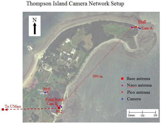
 The primary objective of this study is to evaluate the use of low power low cost networked smart cameras to study and manage coastal inundation. Global climate change is predicted to cause a rise in sea levels of 50cm in the next century, and rising sea levels will in turn increase the rate of shoreline erosion. Therefore, it is critical to understand and track the factors driving this erosion. New technology, such as miniature remote cameras could be a valuable resource in this effort. Cameras could potentially be deployed in large numbers in multi-tier networks to provide expandable intelligence of changing coastal conditions. However, testing is necessary in order to evaluate how and to what degree this is feasible. By testing these cameras on Thompson Island, the investigators will be able to build practical experience in a relevant environment. A secondary objective of the study will be to document the short-term processes of bluff erosion. Peter Rosen, the geologist on the team, will be able to use the video and time-series snapshots to develop an understanding of the dynamics of slumping on the bluff at the northeastern tip of Thompson Island. This bluff is undergoing significant erosion, but the actual erosion events are hard to capture. They only happen at extreme high tide when waves are able to reach the bottom of the bluff. Feeds from the video camera will cut to evaluate these high tide moments with the hope of capturing video of an actual bluff slumping event. The results from this study could lead to further studies in other parts of Boston Harbor and possible reapplication of remote camera technology for other geologic processes. The following diagram shows the camera network as implemented on Thompson Island. Two low-cost low-power cameras are connected through a series of wireless antennas to a base station. The base station is connected by long-distance wireless to an antenna at UMass, which in turn is connected to the UMass intranet. In the following diagram, PS2 antennas are powerful long-range antennas, Nano antennas are shorter range directional antennas, and Pico antennas are very short range (less than 150m) non-directional antennas. All of the antennas require near line-of-site connections, so the network has been designed to fit into the topography of the island, avoiding hills and trees.  Click here to see images and videos from the Thompson Island cameras. This project was made possible thanks to support from Thompson Island, and the National Park Service Harbor Islands. |
||||
|
|
||||